Meteorology
Gatherd and Disinged by: Alireza Nozhat & Yousef Neghabi

Atomsphere

Atomsphere
The atmosphere of Earth is mostly composed of nitrogen (about 78%), oxygen (about 21%), argon (about 0.9%) with carbon dioxide and other gases in trace amounts. Oxygen is used by most organisms for respiration, nitrogen is fixed by bacteria and lightning to produce ammonia used in the construction of nucleotides and amino acids and carbon dioxide is used by plants, algae and cyanobacteria for photosynthesis. The atmosphere helps protect living organisms from genetic damage by solar ultraviolet radiation, solar wind and cosmic rays. Its current composition is the product of billions of years of biochemical modification of the paleoatmosphere by living organisms.
The term stellar atmosphere describes the outer region of a star, and typically includes the portion starting from the opaque photosphere outwards. Stars with sufficiently low temperatures may form compound molecules in their outer atmosphere.
Pressure
Atmospheric pressure is the force per unit area that is applied perpendicularly to a surface by the surrounding gas. It is determined by a planet's gravitational force in combination with the total mass of a column of gas above a location. On Earth, units of air pressure are based on the internationally recognized standard atmosphere (atm), which is defined as 101.325 kPa (760 Torr or 14.696 psi). It is measured with a barometer.
The pressure of an atmospheric gas decreases with altitude due to the diminishing mass of gas above. The height at which the pressure from an atmosphere declines by a factor of e (an irrational number with a value of 2.71828..) is called the scale height and is denoted by H. For an atmospherev
with a uniform temperature, the scale height is proportional to the temperature and inversely proportional to the product of the mean molecular mass of dry air and the local acceleration of gravity at that location. For such a model atmosphere, the pressure declines exponentially with increasing altitude. However, atmospheres are not uniform in temperature, so the exact determination of the atmospheric pressure at any particular altitude is more complex.
Atmospheric escape
Surface gravity, the force that holds down an atmosphere, differs significantly among the planets. For example, the large gravitational force of the giant planet Jupiter is able to retain light gases such as hydrogen and helium that escape from objects with lower gravity. Secondly, the distance from the Sun determines the energy available to heat atmospheric gas to the point where some fraction of its molecules' thermal motion exceed the planet's escape velocity, allowing those to escape a planet's gravitational grasp. Thus, the distant and cold Titan, Triton, and Pluto are able to retain their atmospheres despite their relatively low gravities. Rogue planets, theoretically, may also retain thick atmospheres.
Since a collection of gas molecules may be moving at a wide range of velocities, there will always be some fast enough to produce a slow leakage of gas into space. Lighter molecules move faster than heavier ones with the same thermal kinetic energy, and so gases of low molecular weight are lost more rapidly than those of high molecular weight. It is thought that Venus and Mars may have lost much of
their water when, after being photo dissociated into hydrogen and oxygen by solar ultraviolet, the hydrogen escaped. Earth's magnetic field helps to prevent this, as, normally, the solar wind would greatly enhance the escape of hydrogen. However, over the past 3 billion years Earth may have lost gases through the magnetic polar regions due to auroral activity, including a net 2% of its atmospheric oxygen.[3]
Other mechanisms that can cause atmosphere depletion are solar wind-induced sputtering, impact erosion, weathering, and sequestration—sometimes referred to as "freezing out"—into the regolith and polar caps.
Terrain
Atmospheres have dramatic effects on the surfaces of rocky bodies. Objects that have no atmosphere, or that have only an exosphere, have terrain that is covered in craters. Without an atmosphere, the planet has no protection from meteors, and all of them collide with the surface and create craters.
A rocky body with a thick atmosphere does not have significant craters on its surface. The friction generated when a meteor enters an atmosphere causes the vast majority of it to burn up before hitting the surface. When meteors do impact, the effects are often erased by the action of wind. As a result, craters are rare on objects with atmospheres.
All objects with atmospheres have wind and weather. Wind erosion is a significant factor in shaping the terrain of rocky planets with atmospheres, and over time can
erase the effects of both craters and volcanoes. In addition, since liquids can not exist without pressure, an atmosphere allows liquid to be present at the surface, resulting in lakes, rivers and oceans. Earth and Titan are known to have liquids at their surface and terrain on the planet suggests that Mars had liquid on its surface in the past.
Composition

Earth's atmospheric gases scatter blue light more than other wavelengths, giving Earth a blue halo when seen from space
Initial atmospheric composition is generally related to the chemistry and temperature of the local solar nebula during planetary formation and the subsequent escape of interior gases. The original atmospheres started with the radially local rotating gases that collapsed to the spaced rings that formed the planets.[clarification needed] They were then modified over time by various complex factors, resulting in quite different outcomes.
The atmospheres of the planets Venus and Mars are primarily composed of carbon dioxide, with small quantities of nitrogen, argon, oxygen and traces of other gases.
The atmospheric composition on Earth is largely governed by the by-products of the life that it sustains. Dry air from Earth's atmosphere contains 78.08% nitrogen, 20.95% oxygen, 0.93% argon, 0.04% carbon dioxide, and traces of hydrogen, helium, and other "noble" gases (by volume), but generally a variable amount of water vapour is also present, on average about 1% at sea level. The low temperatures and higher gravity of the Solar System's giant planets—Jupiter, Saturn, Uranus and Neptune—allow them more readily to retain gases with low molecular masses. These planets have hydrogen–helium atmospheres, with trace amounts of more complex compounds.
Structure of the atmosphere

Troposphere
Main article: Troposphere
The troposphere is the lowest layer of Earth's atmosphere. It extends from Earth's surface to an average height of about 12 km, although this altitude actually varies from about 9 km (30,000 ft) at the poles to 17 km (56,000 ft) at the equator,[10] with some variation due to weather. The troposphere is bounded above by the tropopause, a boundary marked in most places by a temperature inversion (i.e. a layer of relatively warm air above a colder one), and in others by a zone which is isothermal with height.[15][16]
Although variations do occur, the temperature usually declines with increasing altitude in the troposphere because the troposphere is mostly heated through energy transfer from the surface. Thus, the lowest part of the troposphere (i.e. Earth's surface) is typically the warmest section of the troposphere. This promotes vertical mixing (hence the origin of its name in the Greek word τρόπος, tropos, meaning "turn"). The troposphere contains roughly 80% of the mass of Earth's atmosphere.[17] The troposphere is denser than all its overlying atmospheric layers because a larger atmospheric weight sits on top of the troposphere and causes it to be most severely compressed. Fifty percent of the total mass of the atmosphere is located in the lower 5.6 km (18,000 ft) of the troposphere.
Stratosphere
Main article: Stratosphere
The stratosphere is the second-lowest layer of Earth's atmosphere. It lies above the troposphere and is separated from it by the tropopause. This layer extends from the top of the troposphere at roughly 12 km (7.5 mi; 39,000 ft) above Earth's surface to the stratopause at an altitude of about 50 to 55 km (31 to 34 mi; 164,000 to 180,000 ft).
The atmospheric pressure at the top of the stratosphere is roughly 1/1000 the pressure at sea level. It contains the ozone layer, which is the part of Earth's atmosphere that contains relatively high concentrations of that gas. The stratosphere defines a layer in which temperatures rise with increasing altitude. This rise in temperature is caused by the absorption of ultraviolet radiation (UV) radiation from the Sun by the ozone layer, which restricts turbulence and mixing. Although the temperature may be −60 °C (−76 °F; 210 K) at the tropopause, the top of the stratosphere is much warmer, and may be near 0 °C.[14]
The stratospheric temperature profile creates very stable atmospheric conditions, so the stratosphere lacks the weather-producing air turbulence that is so prevalent in the troposphere. Consequently, the stratosphere is almost completely free of clouds and other forms of weather. However, polar stratospheric or nacreous clouds are occasionally seen in the lower part of this layer of the atmosphere where the air is coldest. The stratosphere is the highest layer that can be accessed by jet-powered aircraft.
Mesosphere
Main article: Mesosphere
The mesosphere is the third highest layer of Earth's atmosphere, occupying the region above the stratosphere and below the thermosphere. It extends from the stratopause at an altitude of about 50 km (31 mi; 160,000 ft) to the mesopause at 80–85 km (50–53 mi; 260,000–280,000 ft) above sea level.
Temperatures drop with increasing altitude to the mesopause that marks the top of this middle layer of the atmosphere. It is the coldest place on Earth and has an average temperature around −85 °C (−120 °F; 190 K).[12][13]
Just below the mesopause, the air is so cold that even the very scarce water vapor at this altitude can be sublimated into polar-mesospheric noctilucent clouds. These are the highest clouds in the atmosphere and may be visible to the naked eye if sunlight reflects off them about an hour or two after sunset or a similar length of time before sunrise. They are most readily visible when the Sun is around 4 to 16 degrees below the horizon. A type of lightning referred to as either sprites or ELVES occasionally forms far above tropospheric thunderclouds. The mesosphere is also the layer where most meteors burn up upon atmospheric entrance. It is too high above Earth to be accessible to jet-powered aircraft and balloons, and too low to permit orbital spacecraft. The mesosphere is mainly accessed by sounding rockets and rocket-powered aircraft.
Thermosphere
Main article: Thermosphere
The thermosphere is the second-highest layer of Earth's atmosphere. It extends from the mesopause (which separates it from the mesosphere) at an altitude of about 80 km (50 mi; 260,000 ft) up to the thermopause at an altitude range of 500–1000 km (310–620 mi; 1,600,000–3,300,000 ft). The height of the thermopause varies considerably due to changes in solar activity.[9] Because the thermopause lies at the lower boundary of the exosphere, it is also referred to as the exobase. The lower part of the thermosphere, from 80 to 550 kilometres (50 to 342 mi) above Earth's surface, contains the ionosphere.
The temperature of the thermosphere gradually increases with height. Unlike the stratosphere beneath it, wherein a temperature inversion is due to the absorption of radiation by ozone, the inversion in the thermosphere occurs due to the extremely low density of its molecules. The temperature of this layer can rise as high as 1500 °C (2700 °F), though the gas molecules are so far apart that its temperature in the usual sense is not very meaningful. The air is so rarefied that an individual molecule (of oxygen, for example) travels an average of 1 kilometre (0.62 mi; 3300 ft) between collisions with other molecules.[11] Although the thermosphere has a high proportion of molecules with high energy, it would not feel hot to a human in direct contact, because its density is too low to conduct a significant amount of energy to or from the skin.
Exosphere
Main article: Exosphere
The exosphere is the outermost layer of Earth's atmosphere (i.e. the upper limit of the atmosphere). It extends from the exobase, which is located at the top of the thermosphere at an altitude of about 700 km above sea level, to about 10,000 km (6,200 mi; 33,000,000 ft) where it merges into the solar wind.
This layer is mainly composed of extremely low densities of hydrogen, helium and several heavier molecules including nitrogen, oxygen and carbon dioxide closer to the exobase. The atoms and molecules are so far apart that they can travel hundreds of kilometers without colliding with one another. Thus, the exosphere no longer behaves like a gas, and the particles constantly escape into space. These free-moving particles follow ballistic trajectories and may migrate in and out of the magnetosphere or the solar wind.
The exosphere is located too far above Earth for any meteorological phenomena to be possible. However, the aurora borealis and aurora australis sometimes occur in the lower part of the exosphere, where they overlap into the thermosphere. The exosphere contains most of the satellites orbiting Earth.
Clouds

All air contains water, but near the ground it is usually in the form of an invisible gas called water vapor. When warm air rises, it expands and cools. Cool air can't hold as much water vapor as warm air, so some of the vapor condenses onto tiny pieces of dust that are floating in the air and forms a tiny droplet around each dust particle. When billions of these droplets come together they become a visible cloud.
Clouds move with the wind. High cirrus clouds are pushed along by the jet stream, sometimes traveling at more than 100 miles-per-hour. When clouds are part of a thunderstorm they usually travel at 30 to 40 mph.
The characteristics of clouds are dictated by the elements available, including the amount of water vapor, the temperatures at that height, the wind, and the interplay of other air masses.
Cloud Chart

Cirrus clouds
Cirrus clouds are the most common of the high clouds. They are composed of ice and are thin, wispy clouds blown in high winds into long streamers. Cirrus clouds are usually white and predict fair to pleasant weather. By watching the movement of cirrus clouds you can tell from which direction weather is approaching. When you see cirrus clouds, it usually indicates that a change in the weather will occur within 24 hours.

Cirrocumulus clouds
Cirrocumulus clouds appear as small, rounded white puffs that appear in long rows. The small ripples in the cirrocumulus clouds sometime resemble the scales of a fish. Cirrocumulus clouds are usually seen in the winter and indicate fair, but cold weather. In tropical regions, they may indicate an approaching hurricane.
Alto Clouds
Altostratus clouds are gray or blue-gray mid level clouds composed of ice crystals and water droplets. The clouds usually cover the entire sky. In the thinner areas of the clouds, the sun may be dimly visible as a round disk. Altostratus clouds often form ahead of storms with continuous rain or snow.

Altocumulus clouds
Altocumulus clouds are mid level clouds that are made of water droplets and appear as gray puffy masses. They usually form in groups. If you see altocumulus clouds on a warm, sticky morning, be prepared to see thunderstorms late in the afternoon.

Stratus Clouds
Stratus clouds are uniform grayish clouds that often cover the entire sky. They resemble fog that doesn't reach the ground. Light mist or drizzle sometimes falls out of these clouds.

Stratocumulus clouds
Stratocumulus clouds are low, puffy and gray. Most form in rows with blue sky visible in between them. Rain rarely occurs with stratocumulus clouds, however, they can turn into nimbostratus clouds.
Nimbostratus clouds
Nimbostratus clouds form a dark gray, wet looking cloudy layer associated with continuously falling rain or snow. They often produce precipitation that is usually light to moderate.

Cumulus clouds
Cumulus clouds are white, puffy clouds that look like pieces of floating cotton. Cumulus clouds are often called "fair-weather clouds". The base of each cloud is flat and the top of each cloud has rounded towers. When the top of the cumulus clouds resemble the head of a cauliflower, it is called cumulus congestus or towering cumulus. These clouds grow upward and they can develop into giant cumulonimbus clouds, which are thunderstorm clouds.
Cumulonimbus clouds
Cumulonimbus clouds are thunderstorm clouds. High winds can flatten the top of the cloud into an anvil-like shape. Cumulonimbus clouds are associated with heavy rain, snow, hail, lightning and even tornadoes. The anvil usually points in the direction the storm is moving.
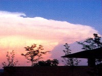
Mammatus clouds
Mammatus clouds are low hanging bulges that droop from cumulonimbus clouds. Mammatus clouds are usually associated with severe weather.

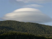
Lenticular clouds
Lenticular clouds are caused by a wave wind pattern created by the mountains. They look like discs or flying saucers that form near mountains.
Fog
![Fog Fog consists of visible cloud water droplets or ice crystals suspended in the air at or near the Earth's surface.[1] Fog can be considered a type of low-lying cloud and is heavily influenced by nearby bodies of water, topography, and wind conditions. In turn, fog has affected many human activities, such as shipping, travel, and warfare.](/en/images/metrology20.jpg)
Fog consists of visible cloud water droplets or ice crystals suspended in the air at or near the Earth's surface. Fog can be considered a type of low-lying cloud and is heavily influenced by nearby bodies of water, topography, and wind conditions. In turn, fog has affected many human activities, such as shipping, travel, and warfare.
WIND SYSTEM
WIND GYREs
A gyre in oceanography is any large system of circulating ocean currents, particularly those involved with large wind movements. Gyres are caused by the Coriolis effect; planetary vorticity along with horizontal and vertical friction, determine the circulation patterns from the wind curl (torque).The term gyre can be used to refer to any type of vortex in the air or the sea, even one that is man-made, but it is most commonly used in oceanography to refer to the major ocean systems.
The following are the five most notable gyres:
Indian Ocean Gyre (generally flowing counter-clockwise)
North Atlantic Gyre
North Pacific Gyre
South Atlantic Gyre
South Pacific Gyre
Other(Tropical gyres,subtropical gyres,subpolar gyres)
Tropical gyres
All of the world's larger gyres
Tropical gyres are less unified and tend to be mostly east-west with minor north-south extent.
Atlantic Equatorial Current System (two counter-rotating circulations)
Pacific Equatorial Current System
Indian Monsoon Gyres (two counter-rotating circulations in northern Indian Ocean)
Subpolar gyres
Subpolar gyres form at high latitudes (around 60°). Circulation of surface wind and ocean water is counterclockwise in the Northern Hemisphere, around a low-pressure area, such as the persistent Aleutian Low and the Icelandic Low. Surface currents generally move outward from the center of the system. This drives the Ekman transport, which creates an upwelling of nutrient-rich water from the lower depths.
Subpolar circulation in the southern hemisphere is dominated by the Antarctic Circumpolar Current, due to the lack of large landmasses breaking up the Southern Ocean. There are minor gyres in the Weddell Sea and the Ross Sea, the Weddell Gyre and Ross Gyre, which circulate in a clockwise direction.
DOLDRUMS WIND
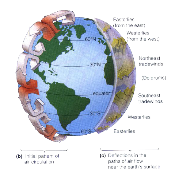
The doldrums is a colloquial expression derived from historical maritime usage, which refers to those parts of the Atlantic Ocean and the Pacific Ocean affected by the Intertropical Convergence Zone, a low-pressure area around the equator where the prevailing winds are calm. The doldrums are also noted for calm periods when the winds disappear altogether, trapping sail-powered boats for periods of days or weeks. The term appears to have arisen in the eighteenth century, when cross-equator sailing voyages became more common. Since this zone is the meeting place of two trade winds, it is also called intertropical convergence zone. They roughly lie between 5°N to 5°S
TRADE WINDS
The trade winds are the prevailing pattern of easterly surface winds found in the tropics, within the lower portion of the Earth's atmosphere, in the lower section of the troposphere near the Earth's equator. The trade winds blow predominantly from the northeast in the Northern Hemisphere and from the southeast in the Southern Hemisphere, strengthening during the winter and when the Arctic oscillation is in its warm phase. Trade winds have been used by captains of sailing ships to cross the world's oceans for centuries, and enabled European empire expansion into the Americas and trade routes to become established across the Atlantic and Pacific oceans.
In meteorology, the trade winds act as the steering flow for tropical storms that form over the Atlantic, Pacific, and southern Indian Oceans and make landfall in North America, Southeast Asia, and Madagascar and eastern Africa, respectively. Trade winds also transport African dust westward across the Atlantic Ocean into the Caribbean Sea, as well as portions of southeastern North America. Shallow cumulus clouds are seen within trade wind regimes, and are capped from becoming taller by a trade wind inversion, which is caused by descending air aloft from within the subtropical ridge. The weaker the trade winds become, the more rainfall can be expected in the neighboring
CONVERGENCE ZONE
convergence zone in meteorology is a region in the atmosphere where two prevailing flows meet and interact, usually resulting in distinctive weather conditions. This causes a mass accumulation that eventually leads to a vertical movement and to the formation of clouds and precipitation. Large-scale convergence, called synoptic-scale convergence, provides weather systems such as baroclinic troughs, low-pressure areas, and cyclones. Small-scale convergence will give phenomena from isolated cumulus clouds to large areas of thunderstorms.
The inverse of a convergence is a divergence.
MONSOON WINDS
Monsoon is traditionally defined as a seasonal reversing wind accompanied by corresponding changes in precipitation, but is now used to describe seasonal changes in atmospheric circulation and precipitation associated with the asymmetric heating of land and sea. Usually, the term monsoon is used to refer to the rainy phase of a seasonally changing pattern, although technically there is also a dry phase. The term is sometimes incorrectly used for locally heavy but short-term rains, although these rains meet the dictionary definition of monsoon.
The major monsoon systems of the world consist of the West African and Asia-Australian monsoons. The inclusion of the North and South American monsoons with incomplete wind reversal has been debated.
The term was first used in English in British India (now India, Bangladesh and Pakistan) and neighbouring countries to refer to the big seasonal winds blowing from the Bay of Bengal and Arabian Sea in the southwest bringing heavy rainfall to the area.The south-west monsoon winds are called 'Nairutya Maarut' in India.
THE MONSOON OF WESTEN AFRICA
The monsoon of western Sub-Saharan Africa is the result of the seasonal shifts of the Intertropical Convergence Zone and the great seasonal temperature and humidity differences between the Sahara and the equatorial Atlantic Ocean. It migrates northward from the equatorial Atlantic in February, reaches western Africa on or near June 22, then moves back to the south by October. The dry, northeasterly trade winds, and their more extreme form, the harmattan, are interrupted by the northern shift in the ITCZ and resultant southerly, rain-bearing winds during the summer. The semiarid Sahel and Sudan depend upon this pattern for most of their precipitation.
THE INDIAN MONSOON WIND
The Indian Monsoon Current refers to the seasonally varying ocean current regime found in the tropical regions of the northern Indian Ocean. During winter, the flow of the upper ocean is directed westward from near the Indonesian Archipelago to the Arabian Sea. During the summer, the direction reverses, with eastward flow extending from Somalia into the Bay of Bengal. These variations are due to changes in the wind stress associated with the Indian monsoon. The seasonally reversing open ocean currents that pass south of India are referred to as the Winter Monsoon Current and the Summer Monsoon Current (alternately, the Northeast Monsoon Current and the Southwest Monsoon Current). The Somali Current, which is strongly linked to the Indian monsoon, is also discussed in this article.
East Asia Monsoon
The East Asian monsoon is a monsoonal flow that carries moist air from the Indian Ocean and Pacific Ocean to East Asia. It affects approximately one-third of the global population, influencing the climate of Japan (including Okinawa), the Koreas, Taiwan, Hong Kong, Macau, the Philippines, Indochina, and much of mainland China. It is driven by temperature differences between the Asian continent and the Pacific Ocean. The East Asian monsoon is divided into a warm and wet summer monsoon and a cold and dry winter monsoon. This cold and dry winter monsoon is responsible for the aeolian dust deposition and pedogenesis that resulted in the creation of the Loess Plateau. The monsoon influences weather patterns as far north as Siberia, causing wet summers that contrasts the cold and dry winters caused by the Siberian High, which counter-balances the monsoon's effect on northerly latitudes.
AUSTRALIAN MONSOON
Also known as the Indo-Australian Monsoon. The rainy season occurs from September to February and it is a major source of energy for the Hadley circulation during boreal winter. The Maritime Continent Monsoon and the Australian Monsoon may be considered to be the same system, the Indo-Australian Monsoon.
It is associated with the development of the Siberian High and the movement of the heating maxima from the Northern Hemisphere to the Southern Hemisphere. North-easterly winds flow down Southeast Asia, are turned north-westerly/westerly by Borneo topography towards Australia. This forms a cyclonic circulation vortex over Borneo, which together with descending cold surges of winter air from higher latitudes, cause significant weather phenomena in the region. Examples are the formation of a rare low-latitude tropical storm in 2001, Tropical Storm Vamei, and the devastating flood of Jakarta in 2007.
PRESSURE SYSTEM
A pressure system is a relative peak or lull in the sea level pressure distribution. The surface pressure at sea level varies minimally, with the lowest value measured 87 kilopascals (26 inHg) and the highest recorded 108.57 kilopascals (32.06 inHg). High- and low-pressure systems evolve due to interactions of temperature differentials in the atmosphere, temperature differences between the atmosphere and water within oceans and lakes, the influence of upper-level disturbances,[jargon] as well as the amount of solar heating or radiational cooling an area receives. Pressure systems cause weather experienced locally. Low-pressure systems are associated with clouds and precipitation that minimize temperature changes through the day, whereas high-pressure systems normally associated with dry weather and mostly clear skies with larger diurnal temperature changes due to greater radiation at night and greater sunshine during the day. Pressure systems are analyzed by those in the field of meteorology within surface weather maps.
HIGH PRESSURE SYSTEM
High-pressure systems are frequently associated with light winds at the surface and subsidence through the lower portion of the troposphere. In general, subsidence will dry out an air mass by adiabatic or compressional heating. Thus, high pressure typically brings clear skies.During the day, since no clouds are present to reflect sunlight, there is more incoming shortwave solar radiation and temperatures rise. At night, the absence of clouds means that outgoing longwave radiation (i.e. heat energy from the surface) is not absorbed, giving cooler diurnal low temperatures in all seasons. When surface winds become light, the subsidence produced directly under a high-pressure system can lead to a buildup of particulates in urban areas under the ridge, leading to widespread haze. If the low-level relative humidity rises towards 100 percent overnight, fog can form.
Strong but vertically shallow high-pressure systems moving from higher latitudes to lower latitudes in the northern hemisphere are associated with continental arctic air masses.The low, sharp temperature inversion can lead to areas of persistent stratocumulus or stratus cloud, known in colloquial terms as anticyclonic gloom. The type of weather brought about by an anticyclone depends on its origin. For example, extensions of the Azores high bubble pressure may bring about anticyclonic gloom during the winter, as they are warmed at the base and will trap moisture as they move over the warmer oceans.
LOW PRESSURE SYSTEM
A low-pressure area, or "low", is a region where the atmospheric pressure at sea level is below that of surrounding locations. Low-pressure systems form under areas of wind divergence that occur in upper levels of the troposphere.The formation process of a low-pressure area is known as cyclogenesis. Within the field of atmospheric dynamics, areas of wind divergence aloft occur in two areas:
on the east side of upper troughs, which form half of a Rossby wave within the Westerlies (a trough with large wavelength, which extends through the troposphere)
ahead of embedded shortwave troughs, which have smaller wavelengths
Diverging winds aloft ahead of these troughs cause atmospheric lift within the troposphere below, which lowers surface pressures as upward motion partially counteracts the force of gravity.Thermal lows form due to localized heating caused by greater sunshine over deserts and other land masses. Since localized areas of warm air are less dense than their surroundings, this warmer air rises, which lowers atmospheric pressure near that portion of the Earth's surface.Large-scale thermal lows over continents help create pressure gradients that drive monsoon circulations. Low-pressure areas can also form due to organized thunderstorm activity over warm water.When such an occurrence occurs over the tropics in concert with the Intertropical Convergence Zone, it is known as a monsoon trough. Monsoon troughs reach their northerly extent in August and their southerly extent in February.
Dew point
Dew point is the temperature to which air must be cooled to become saturated with water vapor. When further cooled, the airborne water vapor will condense to form liquid dew. When air with a high dew point contacts surfaces at colder temperatures, then liquid dew will form on the surfaces as condensation. Dew point is sometimes called frost point when the temperature is below freezing. The measurement of dew point is related to humidity. A higher dew point means there will be more moisture in the air.
land breeze
During the night, the land gives off its heat very quickly and the air in contact with it also cools rapidly resulting in a high pressure over the land. The temperature of the sea surface, and hence the temperature of the air in contact with it, remains fairly constant resulting in a relatively low pressure over the sea. The isobars run roughly parallel to the coast.
Remains fairly constant resulting in a relatively high pressure over sea. The isobars run roughly parallel to the coast. Since the distance between the high and the low pressure areas is quite small and the pressure gradient is fairly high, the wind blows directly across the isobars from the HP over the sea, towards the LP over land. The sea breeze usually
sets in by about 1000 or 1100 hours local time, reaches a maximum force of 3 to 4 by about 1400 hours and dies down about sunset. In rare cases, sea breezes have been detected as far away as 100 miles from the coast.
On top, the level of mercury in the tube would drop until it became equal to the level of mercury in the towl.
Since the distance between the HP over land and the LP over sea is small, the wind blows directly across the isobars from the land towards the sea. The land breeze sets in a couple of hours after sunset and blows until about half hour after sunrise.
Sea breeze
A sea breeze or onshore breeze is any wind that blows from a large body of water toward or onto a landmass; it develops due to differences in air pressure created by the differing heat capacities of water and dry land. As such sea breezes are more localised than prevailing winds. Because land absorbs solar radiation far more quickly than water, a sea breeze is a common occurrence along coasts after sunrise. By contrast, a land breeze or offshore breeze is the reverse effect: dry land also cools more quickly than water and, after sunset, a sea breeze dissipates and the wind instead flows from the land towards the sea. Sea breezes and land breezes are both important factors in coastal regions' prevailing winds.[1] The term offshore wind may refer to any wind over open water.
Meteorology Instruments
Mercury Barometer
The mercury barometer is an instrument for measuring atmospheric pressure. It was invented by an Italian scientist named Torricelli in 1643.
Principle
In its simplest form, the mercury barometer consists of a glass tube about one metre long, closed at one end, filled with mercury and inverted into a bowi containing mercury (see accompanying sketch). While inverting the tube, a finger should be palced over the open end and removed only after the end has been immersed in the mercury in the bowl. It will be noticed that the mercury level in the tube drops by a certain a mount and then remains steady. This is because atmospheric pressure, acting on the surface of mercury in the bowl, balances the weight of mercury in the tube. Atmospheric pressure, therefore, is the weight of mercury above the level of mercury in the bowl (for further details of atmospheric pressure, please see chapter).
If any air is present in the top of the inverted tube, the barometer would show lower than correct reading. If air was allowed to freely enter the space.
Marine barometers
Marine barometers that are used on board should be fastened to a bulkhead for safety's sake.
Thermometer
A thermometer is a device that measures temperature or a temperature gradient. A thermometer has two important elements: (1) a temperature sensor (e.g. the bulb of a mercury-in-glass thermometer) in which some physical change occurs with temperature, and (2) some means of converting this physical change into a numerical value (e.g. the visible scale that is marked on a mercury-in-glass thermometer). Thermometers are widely used in industry to control and regulate processes, in the study of weather, in medicine, and in scientific research.
A capillary tube of glass is attached to a bulb containing mercury, evacuated of air and sealed at its open end. When heated, the mercury in the bulb expands into the capillary tube. When the temperature increases, the mercury in the bulb expands and the length of mercury in the column gets more. When the temperature decreases, the mercury in the bulb contracts and the length of mercury in the column gets less.
The tube is graduated with tow reference poinst the freezing point and the boiling point of water. The graduation differs from type to type.
Reading a thermometer
(i) Stand as far away as practicable so that body heat will not affect the thermometer.
(ii) keep eye at same level as top of mercury column to avoid error of parallax.
(iii) Read the thermometer by judging it to the nearest tenth of a degree. If this is not possible, then read it to the nearest half of a degree.
While using the screen, the heat radiated by the mercury is partially retained inside the screen and the reading shown by the thermometer will be closer to the true reading than when in the open.
The hygrometer (also called psychrometer)
The hygrometer is an instrument for obtaining the relative humidity and/ or dew point temperature of air. The type in use at sea on merchant ships is called the Masons hygrometer or wet-and-dry-bulb hygrometer or psychrometer.
Description
The hygrometer consists of two identical Celsius thermometers, one called the dry bulb thermometer and the other, the wet bulb thermometer. The wet bulb thermometer has a thin, single layer of muslin or cotton (starch free) tied around the bulb by a few strands of cotton wick. The extra length of the strands of wick is immersed in a bottle of distilled water. Both the thermometers are enclosed in a special, ventilated, wooden box called the Stevenson screen, described later.
Principle
Because of capillary action, the muslin always remains damp water is drawn upwards, from the bottle through the strands of wick. If the atmosphere is dry, rapid evaporation takes place from the muslin. Since evaporation causes cooling, the wet bulb thermometer will show a much lower reading than the dry bulb thermometer. If the atmosphere is humid, evaporation from the muslin will be slow, and less cooling of the wet bulb will take place. The reading of the wet bulb thermometer will then be not much lower than that of the dry bulb thermometer.
The world Meteorological Organisation has adopted the Celsius type where the freezing point of water is and its boiling point, 100 . The length of the tube between 0 and 100 is divided into 100 equal parts. Since air temperature can fall below , the thermometers on ships are usually graduated on the lower side of , down to about -20 or so.
There are two other types of graduation and they are shown here for academic interest only.
Freezing poing of water Boiling point of water.
Formerly called Centigrade.
The Stevenson screen
This is a wooden box specially constructed to house a hygrometer. It was invented by Thomas Stevenson (father of Robert Louis Stevenson).
It is a wooden cupboard with a hinged door. The door, the back and the two sides, are all fitted with louvers or slats which let air circulate freely without letting in direct solar radiation or re-radiated heat from ship structure. The louvers also keep out rain and spray. There are various types of Stevensons screens. The type found on ships is the portable type.
If sunlight is allowed to fall directly on the thermometer it will get very hot and the reading shown by it will be the temperature of the instrument itself, not that of the atmosphere inside the screen, the thermometer will show the temperature of the atmosphere because of the sjade amd the free circulation of air.
During the night, if the thermometer was out in the open, its bulb would radiate out its heat very quickly, much quicker than the air and would thus show a lower than true reading of atmospheric temperature. The thermometer will then show the temperature of the instrument itself, not that of the atmosphere.
Anemo meter
An anemometer is a device used for measuring the speed of wind, and is also a common weather station instrument. The term is derived from the Greek word anemos, which means wind, and is used to describe any wind speed measurement instrument used in meteorology.
Vane anemometers
One of the other forms of mechanical velocity anemometer is the vane anemometer. It may be described as a windmill or a propeller anemometer. Unlike the Robinson anemometer, whose axis of rotation is vertical, the vane anemometer must have its axis parallel to the direction of the wind and therefore horizontal. Furthermore, since the wind varies in direction and the axis has to follow its changes, a wind vane or some other contrivance to fulfill the same purpose must be employed.
A vane anemometer thus combines a propeller and a tail on the same axis to obtain accurate and precise wind speed and direction measurements from the same instrument. The speed of the fan is measured by a rev counter and converted to a windspeed by an electronic chip. Hence, volumetric flowrate may be calculated if the cross-sectional area is known.
In cases where the direction of the air motion is always the same, as in ventilating shafts of mines and buildings, wind vanes known as air meters are employed, and give satisfactory results.
Information presented are collected from different internet sources and is for training purpose only

